

You can find on this page the Ukraine geographical map to print and to download in PDF. The Ukraine geographic map presents the topography, elevation, rivers, mountains, climate and physical features of Ukraine in Europe.

The Ukraine physical map shows landform and geography of Ukraine. This geographical map of Ukraine will allow you to discover physical features of Ukraine in Europe. The Ukraine physical map is downloadable in PDF, printable and free.
Ukraine is the second largest country in Europe, bordering the Black Sea, between Poland and Russia as you can see in Ukraine physical map. Comparatively, Ukraine is slightly smaller than the state of Texas with a total area of 603,700 sq km (233,090 sq mi). Ukraine shares boundaries with Belarus on the North, Russia on the East, the Black Sea on the South, Romania, Moldova, Hungary, and Slovakia on the West, and Poland on the North West. Ukraine location is one of strategic importance at the crossroads between Europe and Asia. Its physical land boundary totals 4,663 km (2,897 mi) and its coastline is 2,782 (1,729 mi). Ukraine capital city, Kiev, is located in the north central part of the country.
Ukraine physical land soil, chernozem (black soil), is very fertile. When the Ukraine was part of the former Soviet Union it was called the country "bread basket." A steppe zone covers about a third of the southern region of the country. Mixed shrubs, grasses, and evergreens can be found along the Mediterranean-like zone of the Crimean coast as its shown in Ukraine physical map. Forest regions include such tree species as beech, linden, oak, and spruce. European bison, fox, and rabbits can be found living on the vast steppes of the country. As of 2002, there were at least 108 species of mammals, 245 species of birds, and over 5,100 species of plants throughout the country.
As observed on the physical map of Ukraine above, about 5% of the country is mountainous. The northern reaches of the Carpathian Mountains stretch across western Ukraine. The country highest point is located there; Hoverla Mountain, at 2061 m (6762 ft) tall. It has been marked on the map above by a yellow upright triangle. As can be seen on the map above, the southern lowland of Ukraine continues into the Crimean Peninsula, a peninsula jutting into the sea from southern Ukraine via the Perekop Isthmus. It is a disputed territory. Much of central Ukraine is covered by plateaus and fertile plains (steppes), somewhat hilly areas of grasslands and shrublands.

Ukraine topographic map shows the physical features of Ukraine. This topographical map of Ukraine will allow you to discover landforms and geographical of Ukraine in Europe. The Ukraine topographic map is downloadable in PDF, printable and free.
The topography of Ukraine consists mainly of fertile plains (steppes) and plateaus. Mountains (Carpathians) are found only in the west and in the Crimean Peninsula in the extreme south. Abut 57% percent of the land in Ukraine is arable with approximately 4% under irrigation as you can see in Ukraine topographic map. The most important river in Ukraine is the Dnipro (Dneiper), the third longest river in Europe. It serves as a major source of hydro-electric power. Other major rivers include the Danube, Western Buh, the Tisza, the Pripyat, and the Desna. Near the Sea of Azov can be found the Donets Ridge and the Near Azov Upland. The snow melt from the mountains feeds the rivers, and natural changes in altitude form sudden drops in elevation and give rise to waterfalls.
The landscape of Ukraine consists mostly of fertile plains (or steppes) and plateaus, crossed by rivers such as the Dnieper (Dnipro), Seversky Donets, Dniester and the Southern Bug as they flow south into the Black Sea and the smaller Sea of Azov as its shown in Ukraine topographic map. To the southwest, the delta of the Danube forms the border with Romania. Ukraine various regions have diverse geographic features ranging from the highlands to the lowlands. The country only mountains are the Carpathian Mountains in the west, of which the highest is the Hora Hoverla at 2,061 metres (6,762 ft), and the Crimean Mountains on Crimea, in the extreme south along the coast. However Ukraine also has a number of highland regions such as the Volyn-Podillia Upland (in the west) and the Near-Dnipro Upland (on the right bank of Dnieper); to the east there are the south-western spurs of the Central Russian Upland over which runs the border with the Russian Federation.
Ukraine occupies the southwestern portion of the Russian Plain (East European Plain) as its mentioned in Ukraine topographic map. The country consists almost entirely of level plains at an average elevation of 574 feet (175 metres) above sea level. Mountainous areas such as the Ukrainian Carpathians and Crimean Mountains occur only on the country borders and account for barely 5 percent of its area. The Ukrainian landscape nevertheless has some diversity: its plains are broken by highlands—running in a continuous belt from northwest to southeast—as well as by lowlands. The rolling plain of the Dnieper Upland, which lies between the middle reaches of the Dnieper (Dnipro) and Southern Buh (Pivdennyy Buh, or the Boh) rivers in west-central Ukraine, is the largest highland area; it is dissected by many river valleys, ravines, and gorges, some more than 1,000 feet (300 metres) deep.

The Ukraine elevation map shows the different altitudes of Ukraine. This altitude map of Ukraine will allow you to know where are the highest and lowest regions of Ukraine in Europe. The Ukraine elevation map is downloadable in PDF, printable and free.
About 95% of the country is flat, because it is located on the territory of the East European Plain. Ukraine maximum elevation: 5,163 m and its average elevation: 256 m. There are only two regions in the country where there are mountains: in the western part of Ukraine are the Eastern Carpathians, part of the Carpathian Mountains, a mountain range that spans Central and Eastern Europe. There is the highest mountain in Ukraine, Mount Hoverla, at 2061 meters as you can see in Ukraine elevation map. In the southern part of the Crimean Peninsula are the Crimean Mountains, which stretch along the southeast coast of the Black Sea for a length of about 150 km. Roman-Kosh is the highest elevation of the Crimean Mountains with 1545 m.
Mount Hoverla (, Hoverla; Hóvár; Hovârla; Goverla, Howerla) at 2061 m, is the highest elevation mountain in Ukraine and part of the Carpathian Mountains. The mountain is located in the Eastern Beskids, in the Chornohora region as its shown in Ukraine elevation map. The slopes are covered with beech and spruce forests, above which there is a belt of sub-alpine meadows called polonyna in Ukrainian. At the eastern slope there is the main spring of the Prut River. The name is of Hungarian origin and means 'snow fortress'. Hoverla is composed of sandstone, a sedimentary rock type. The date of the first ascent is unknown. In late 19th century the mountain became a notable tourist attraction, especially among tourists from nearby cities of Galicia. In 1880 the first tourist route between the peak of Hoverla and Krasny Luh was marked by Leopold Wajgel of the Galician Tatra Society. The following year the first tourist shelter was founded there.
The western part of Chornohora is heavily gouged (the relative height of Petros is 300 m) as its mentioned in Ukraine elevation map. The eastern part is a massive, monotonous range with peaks over 1900 m high: Hoverla (2061); Shpytsi, (1997); Tomnatyk (2018); Pip Ivan (2026) and a minimum elevation of 1750 m. Short ranges branch off from the main range. The slopes of Chornohora, which are dissected by narrow valleys 1000 m or more in width, contrast with the almost level ranges, which are the remains of former peneplains. The western part of Chornohora, containing the Petros Peak (2020 m), lies in Transcarpathia in the basin of the Tysa river. The two parts of Chornohora are separated by a deep pass (alt 1550 m).

The rivers in Ukraine map shows the principal rivers with their names of Ukraine. The rivers map of Ukraine will allow you to find the main rivers which flow in and through Ukraine in Europe. The Ukraine rivers map is downloadable in PDF, printable and free.
The entire country has several rivers running through it. Almost all the major rivers in Ukraine flow northwest to southeast through the plains to empty into the Black Sea and the Sea of Azov. The Dnieper River as you can see in Ukraine rivers map, with its hydroelectric dams, huge reservoirs, and many tributaries, dominates the entire central part of Ukraine. Of the total course of the Dnieper, 609 miles (980 km) are in Ukraine, making it by far the longest river in the country, of which it drains more than half. Like the Dnieper, the Southern Buh, with its major tributary, the Inhul, flows into the Black Sea as you can see in Ukraine rivers map. To the west and southwest, partly draining Ukrainian territory, the Dniester (Dnistro) also flows into the Black Sea; among its numerous tributaries, the largest in Ukraine are the Stryy and the Zbruch.
The Danube River spans a length of 1,777 miles and is the second longest river in Europe. It is the longest river that passes through Ukraine, although it also runs through several other countries as well. Ukraine is the last country to see the Danube before it empties into the Black Sea. It creates the Danube Delta in both Ukraine and Romania. Around 272 square miles of its total 1,603 square miles are in Ukraine. In this delta, the Danube splits into 3 rivers, becoming the Chilia, the Sulina, and the Saint George as its shown in Ukraine rivers map. The area creates 23 major ecosystems, including the Pannonian Steppe grasslands, wetlands, swamps, and the "before-delta" where freshwater and saltwater mix. The third longest river that runs through the country is the Dniester. It has a total length of 846 miles, 247 of which are in nearby Moldova. The 600 miles running through Ukraine create the Dniester Canyon, which is between 260 and 660 feet. The canyon area hosts arboreal and shrub-like trees as well as a number of other plant and animal species. This river is considered to have the cleanest waters in the country.
The rivers within the nation of Ukraine face several environmental threats, including urban development, tourism, agricultural runoff, industrial pollutants, and fishing as its mentioned in Ukraine rivers map. Of note, is the risk of radioactive waste contamination. The previously mentioned Dnieper river is near a radioactive dump site and near the Chernobyl Nuclear Power Plant, a restricted zone with high levels of radioactive contamination after the 1986 accident. Developments along the rivers and within the Danube Delta are altering the ecosystem and disrupting the breeding patterns of fish. In addition, agricultural runoff and overfishing have resulted in decreased fish populations.

The mountains in Ukraine map shows the principal mountains with their names in Ukraine. The mountains map of Ukraine will allow you to find the main mountains ranges and highest mountains of Ukraine in Europe. The Ukraine mountains map is downloadable in PDF, printable and free.
There are only two mountain ranges in Ukraine, the Carpathian Mountains, and the Crimean Mountains. The Carpathian Mountain Ranges are the second longest range in Europe and stretch over a distance of 932 miles as you can see in Ukraine mountains map. The ranges are divided into three sections, namely the Western Carpathians, the Eastern Carpathians, and the Southern Carpathians. The Eastern Carpathians stretch through Poland, Eastern Slovakia, Ukraine, and into Romania. The Crimean mountain ranges, on the other hand, run parallel to the South-East of Crimean Tatar (Back Sea). Mount Hoverla is the highest point in Ukraine and is part of Carpathian Mountain ranges, reaching an elevation of 6,762 feet above sea level. Mount Hoverla is composed of sandstone, and the cap is snow covered. The slopes are covered with beech and spruce forests above which a belt of sub-alpine meadows are found.
Pip Ivan Chornohora is part of the Carpathians ranges and, with an elevation of 6,634 feet above sea level, it is the third highest peak in the country. The mountain was a center of contention from 1918 until 1939 when the Polish border troops made an offensive attack and took over the area. The Polish government built up an impressive astronomical and meteorological observatory center at the summit of this mountain as its shown in Ukraine mountains map. The mountain was later back to the Ukrainian government, and the observatory center is currently was ruined. This mountain is a major tourist attraction site especially to nature lovers. There are several historical and architectural monuments as well as beautiful alpine meadows and woods. Temperatures in the Pip Ivan are not extremely low, and the lowest ever recorded temperature is 5 degrees. The common activities in the mountain b the visitors is cycling, riding, hiking and rating.
Petros is a Greek word which is loosely translated to mean "the rock". Its peak sits at an elevation of 6,630 feet above sea level as its mentioned in Ukraine mountains map. The mountain has been inscribed on the Unesco World Heritage Site list as a natural site. The most notable monument on top of the Petros Mountain is ruins of an Alpine church which was built in the year 1907. The area is popular among amateur mountaineers as the mountain is simple to ascend. The first ascent is not documented. Due to its height and good weather, one can clearly view the panorama of the mountains and scenery. The Hoverla and Pip Ivan mountains are visible to the south East while the West one can see the highest point of the Apshinets Ridge. Tourists fancy the beautiful scenery. The nearby cities of Yersinia, Borsa, and Kolomya offer hospitality services to the tourists.

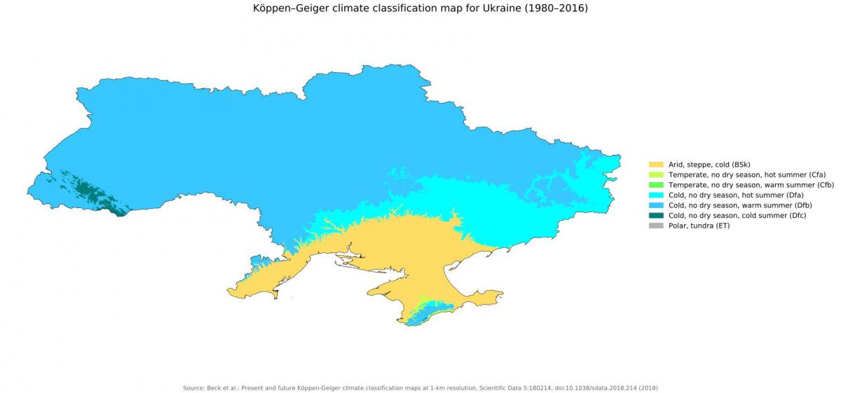
The Ukraine climate map shows average temperature and climate zones of Ukraine. This climate map of Ukraine will allow you to know weather, average precipitation, average sunshine and different climates of Ukraine in Europe. The Ukraine climate map is downloadable in PDF, printable and free.
Ukraine is in a temperate climatic zone that is influenced by humid and moderately warm air masses originating from the Atlantic Ocean. According to the Koeppen-Geiger classification, the country has a Dfb climate which is a humid snow climate. The average temperatures in the warmest month are between 50 and 71.6-degree Fahrenheit while the coldest months experience temperatures of 26.6 degrees Fahrenheit and 50 degrees Fahrenheit as you can see in Ukraine climate map. In the eastern inland area, the climate is classified as Bsk which is characterized by cold and dry weather, the summers are dry, and the average annual temperatures are less than 64.4 degrees Fahrenheit. The coastal regions of the Black Sea have a Cfa climate which is characterized by a humid, warm temperate climate. Generally, the weather is dry and continental with warm and dry summers and relatively severe winters. The summers become progressively warmer towards the south. Areas overlooking the Black Sea to the south have milder weather during winter.
The precipitation in Ukraine occurs quite frequently but is however not abundant in many areas of the country. The vast inland areas which are occupied by hills and plains receive average annual precipitation of between 20 and 23.5 inches as its shown in Ukraine climate map. Summer is the rainiest season due to afternoon thunderstorms. The winter season is not dry and experiences frequent precipitation in the form of light snow. In areas bordering the Black Sea precipitation is not as prevalent and is below 20 inches annually. During summer, thunderstorms are rare. The rainiest regions in the country are the Carpathian Mountains and the Crimean Mountains. In the Carpathian Mountains, the precipitation reaches about 47 inches in a year while the Crimean Mountains receive about 40 inches in a year. Some regions to the west of the Carpathian Mountains receive about 27.5 inches of precipitation per year. During winter, gray skies are prevalent with the sun barely shining. During summer the sun often shines especially on the shores of the Black Sea.
During spring the sunshine hours and temperatures are relatively higher in Ukraine. During May, the temperatures become more pleasant especially in the latter period of the month. The Ukranian summer is quite sunny and warm and at times experiences thunderstorms in the central and northern region. The highest temperatures happen in July, reaching 79 degrees Fahrenheit in the north and 77-degree Fahrenheit in the far north as its mentioned in Ukraine climate map. In southern areas and coastal areas of the Black Sea temperatures reach 81 or 82-degree Fahrenheit. Summer conditions on the Black Sea coast areas such as Crimea are similar to those experienced in the French Riviera and Liguria, but the rain occurs more frequently. Temperatures in autumn decrease considerably. In the Black Sea region, conditions are pleasant in September with highs of about 73 degrees Fahrenheit while areas in the north the temperatures are cooler with highs of about 64 or 66-degree Fahrenheit. During winter, temperatures are below freezing (32 degrees Fahrenheit) in most areas except Crimea. Towards the south, temperatures increase a little but are still below freezing point.